
Reimagining Risk to Make Wildfire “Knowable”
Bellwether’s new partnership with Hiscox aims increase the availability of fire insurance for homeowners throughout California
One of the most striking elements of the images and videos from the Los Angeles fires in January was the wind. Hurricane-force winds, ripping through the Palisades, bending palm trees to their knees and carrying embers for miles. It felt apocalyptic, in part, because this was a fire and not a hurricane—a natural disaster that was so awful, it looked like an entirely different event. This is the new reality of wildfire in the world: shocking intensity and damage in places we never thought possible.
For the last five years, the Bellwether team has been working with scenes like these in mind, driven by the urgent need to create new tools that will enable businesses, communities, and emergency responders to more effectively prepare for, respond to, and recover from cataclysmic natural disasters.
Our moonshot? To create the world’s first “prediction engine” for Earth and everything on it. Bellwether’s mission is to power adaptation for a changing planet. Our team has developed a technology platform that combines AI with real-time earth observation data to provide unprecedented insights across all stages of natural disasters, from forecasting to preparation to rapid response. We decided to tackle wildfire first because it is an urgent and growing problem, and there is a significant opportunity for new technologies to make a huge difference.
A Burning Challenge for Insurers
The insurance industry feels this urgency acutely. As Astro Teller and I discussed in The Moonshot Podcast, insurance isn't just about policies and premiums – it's the invisible thread connecting our present to our future, underpinning the economic and social stability that lets communities thrive.
Yet for years, the insurance industry has grappled with a lack of accurate, forward-looking wildfire risk data. Current models offer static snapshots based on historical information, predicting risk only within a week or two—largely unhelpful for insurers who need to plan coverage years in advance. Traditional forecasting methods haven't kept pace with rapidly changing fire conditions, either. The drivers of wildfire—vegetation, weather, and human activity—evolve constantly, requiring comprehensive analysis of vast environmental datasets from satellites and sensors. Until now, no technology could effectively parse and analyze this scale of information.

Bellwether includes 600 layers of geodata such as canopy, vegetation and precipitation.
Redefining Risk with AI
Bellwether takes an important step in solving this challenge this challenge by delivering what the industry needs: precise wildfire risk predictions for individual 100-by-100 meter areas, up to five years in advance. Our machine learning models process 20 years of comprehensive data across 600 geodata layers—vegetation patterns, meteorological records, fire history, landscape features, and human factors. Critically, Bellwether captures high-resolution wind data, because as the LA fires demonstrated, wind conditions often determine whether fires spread or get contained. Using AI and Google-scale computing power, Bellwether analyzes billions of Earth data points in real-time, completing in minutes what traditionally takes analysts months. This enables unprecedented accuracy in long-term wildfire risk assessment for insurance decision-making.
To test and verify our predictions, Bellwether applies rigorous backtesting methodologies from the AI industry to insurance. We test our models by predicting past years' wildfire risk—say, 2018—then comparing against what actually happened, ensuring our models never "peek" at data from the year they're predicting. The results demonstrate extraordinary accuracy, giving our partners transparent, trustworthy insights.
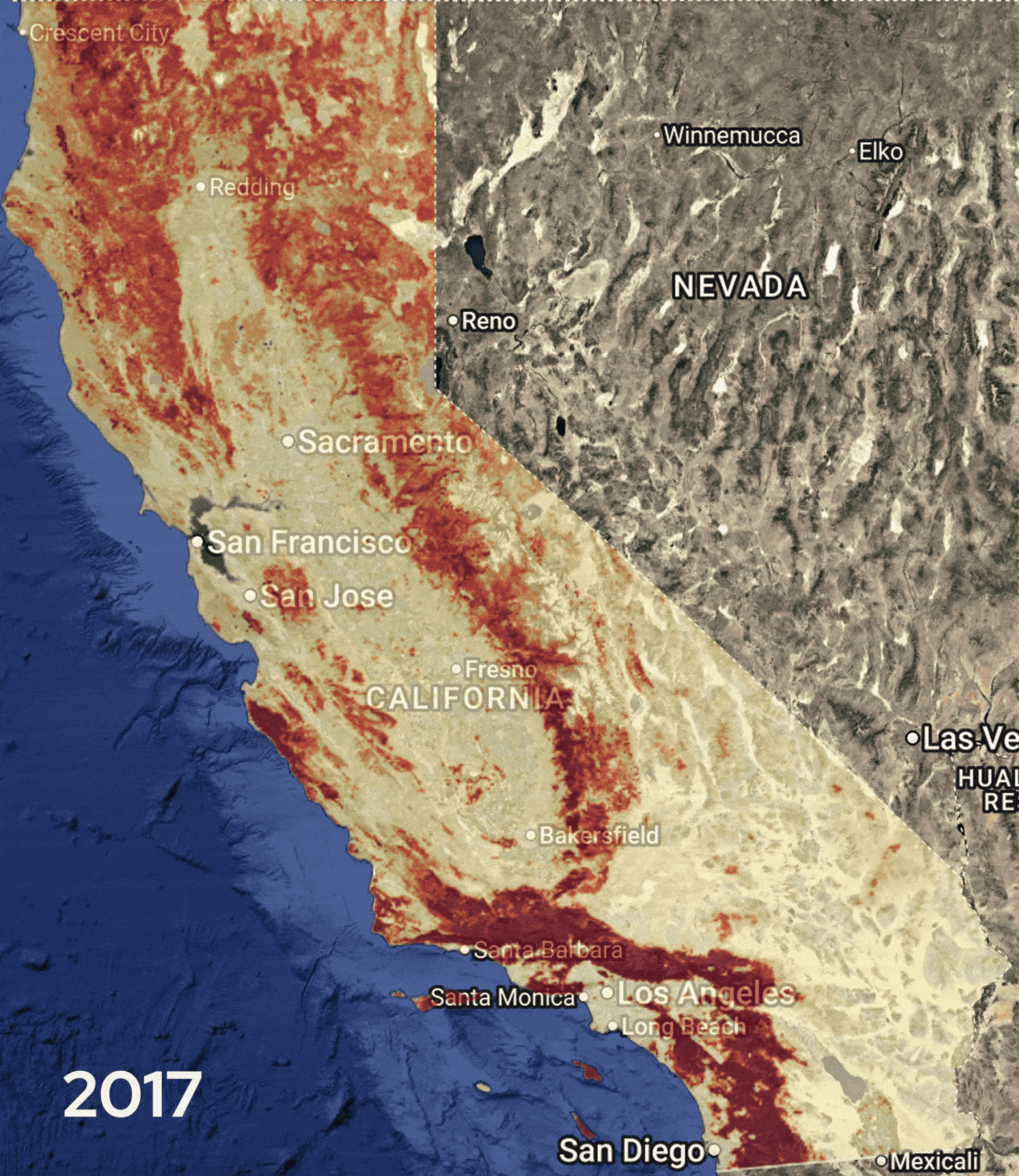
This shows Bellwether’s one-year wildfire predictions from 2017-2024. Each year was trained on data from the years prior, with no exposure to data from the year of prediction. Each map Bellwether generated was around 90% accurate at identifying areas that burned in the year of prediction to be highest risk, and areas that did not burn to be lowest risk. Deep red indicates areas that have a 3% or higher risk of being within a wildfire perimeter, while the light yellow areas have an under 0.1% likelihood of being within a wildfire perimeter during this timeframe.
This AI-powered approach enables Bellwether to offer something unprecedented: absolute risk scores. Instead of vague categories like "low," "medium," and "high" risk, Bellwether provides numerical probability scores on a 0-1 scale. Rather than simply labeling an area in Lake Tahoe’s forests as "high risk," we can tell an underwriter that a specific home has a 1.2% probability of being inside a fire perimeter in the coming year. Bellwether's models include detailed explanations of the factors driving each risk score, which are updated multiple times annually to reflect changing conditions. This precision allows underwriters to make more informed, sustainable decisions about where and how they provide coverage.
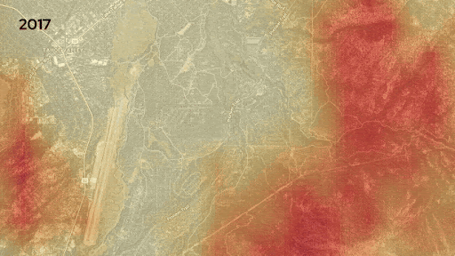
This gif showcases the change in risk over the past few years in the South Lake Tahoe area. Bellwether creates maps like these to visualize risk. Dark red areas indicate a 3% or higher risk of being within a wildfire perimeter, while the light yellow areas have an under 0.1% likelihood of being within a wildfire perimeter during this timeframe.
A Groundbreaking Partnership with Hiscox
Today we’re pleased to share that Hiscox, the global specialist insurer, will be integrating Bellwether's AI-powered wildfire model into their risk scoring and modeling framework. The goal of this partnership is to increase the availability of insurance to homeowners in California. By layering Bellwether's precise predictions into its multi-model framework, Hiscox will be able to more accurately assess wildfire risk, enabling them to offer fairer pricing and wider coverage to more homeowners. After just a few weeks, Bellwether has already helped them provide additional insurance options for California homeowners. This is because Bellwether's insights reveal areas of low risk inside broader areas previously deemed too risky to insure.
This partnership builds on our work over the last few years with Swiss Re in Australia, Canada, and the United States. We enable Swiss Re Solution's tools to quantify wildfire potential and improve risk selection in the underwriting process of their customers. It's important to note that Bellwether does not automate decisions about denying or pricing coverage. Instead, it equips underwriters with the detailed insights needed to offer coverage more responsibly and enable future resilience in wildfire-prone communities.
Building Tools for a More Resilient Future
We started developing Bellwether with wildfire because of its complexity: wildfire touches both natural systems and the built environment, and it changes over time. Now that we have proven our technology, we see incredible opportunities for precise geospatial intelligence to unlock value across a range of industries.
Matching capital to risk with geospatial data is no longer just the work of insurance companies. In an increasingly unpredictable world, cities and businesses large and small face complex decisions that depend on comprehensive, high-resolution, and understandable information about the Earth. Where should we build new housing? How should we invest in critical infrastructure like the electric grid? How can we develop while continuing to protect natural resources like forests or water basins? Bellwether aims to provide solutions that enable this work.
AI, powered by geospatial tools and insights, is making it faster and easier to ask questions about the future using location-based data. As demonstrated in our collaboration with Google Research, AI can quickly and accurately reason about complex, multi-step geospatial problems. For example, after Hurricane Helene, Bellwether helped first responders understand the damage extent, infrastructure status, and economic impact within hours—not days.
Bellwether created many of the geospatial agents featured in this video. This technology makes it easy for first responders, urban planners, public health experts, and others to ask simple questions about complex geospatial information and receive clear, comprehensive answers to help them plan, respond, and recover from natural disasters and more.
Unlocking New Opportunities with Geospatial Data
Building resilience isn't just about managing risk—it's about finding new opportunities. In the same way Bellwether's AI is revealing new patterns and insights into wildfires to help insurers make better decisions, these same tools could help a retail chain identify the safest locations for new stores to avoid flood-prone areas, help a utility company identify new transmission routes to avoid wildfire corridors, or help a global manufacturer understand emerging environmental risks to their supply chain.
Just as excel tools made spreadsheets accessible to everyone, Bellwether aims to make exploring information about the physical world fast and intuitive. We believe the key is making that geospatial data easy to understand through compelling visualizations. When the physical world becomes more “knowable,” and when businesses can easily use knowledge about their environment to inform daily decisions, entirely new markets and opportunities for geospatial data will emerge. Applying AI to hard problems and disparate datasets about the Earth and the built environment is where Bellwether is headed, but we can't get there alone. If you’re interested in being part of this future, please get in touch.